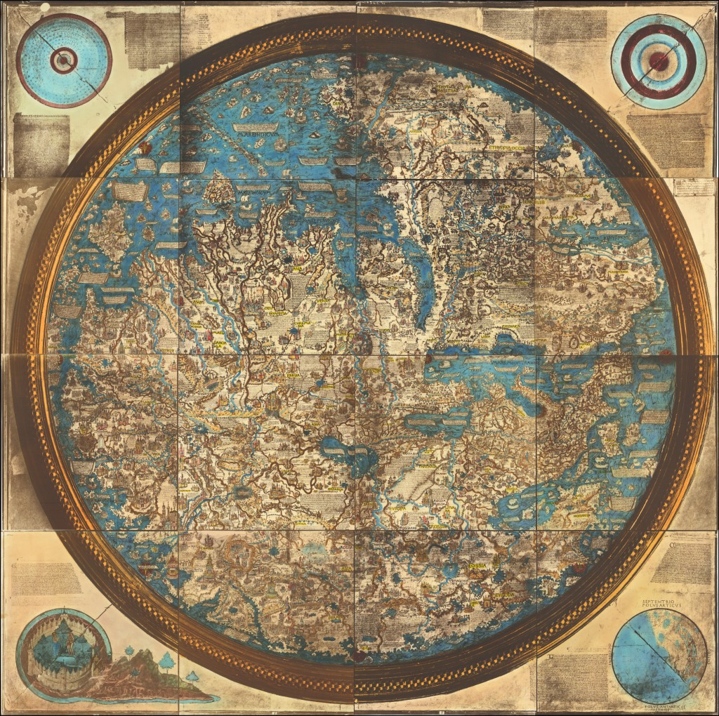
The Fra Mauro Map, created in 1459 by the Venetian cartographer Fra Mauro, is an iconic and significant map from the Renaissance era. Commissioned by the wealthy merchant and explorer, Afonso V of Portugal, this map is renowned for its exceptional craftsmanship and attention to detail. Measuring approximately 2.3 meters in diameter, the Fra Mauro Map offers a unique perspective on the world as understood during the 15th century.
What sets the Fra Mauro Map apart is its meticulous rendering of geographic features, including continents, countries, cities, rivers, and mountain ranges. It was one of the first maps to provide a comprehensive representation of the known world based on a combination of existing knowledge, exploratory accounts, and cartographic innovation. Fra Mauro incorporated information from various sources, including firsthand reports from travelers and explorers, resulting in a remarkably accurate depiction of the time.
The map’s aesthetic appeal lies in its intricate design and rich artistic elements. It features vibrant colors, intricate illustrations of ships and sea monsters, and finely detailed landscapes. Fra Mauro’s map was a visual masterpiece, blending scientific cartography with artistic craftsmanship. It demonstrated a remarkable level of skill and dedication, with each detail thoughtfully executed.
Beyond its artistic and cartographic value, the Fra Mauro Map also offers valuable historical insights and embodies the breadth of knowledge that was known to Medieval mapmakers and explorers. Interestingly, much of the novel information present on the map was lost to early modern cartographers when printed Ptolemy atlases proliferated in the last decades of the 15th century, replacing the manuscript Mappa Mundi tradition.
The Fra Mauro map includes, among other items, the following important cartographic information:
- The Indian Ocean is shown “open”, with a sea transit below southern Africa connecting it with the Atlantic. This was not rediscovered until Vasco da Gama’s 1497-’99 sea voyage to India.
- The Indian Ocean likewise connects to the Pacific Ocean.
- Madagascar is possibly shown and labeled “DIAB”. The first official record of a European seeing Madagascar was Diogo Dias in 1500.
- A large river is shown stretching far into the interior in southern Africa, possibly representing the Zambezi. The river is labeled: “flume xebe”
- The Tigris, Indus, Ganges, Yellow, and Yangtze Rivers are depicted.
- Japan is shown “Ixola de cimpagu”. This is the first known Western depiction of Japan.
- The Korean Peninsula is illustrated.
Ironically, though Fra Mauro was superseded by Ptolemy at the end of the 15th century, he wrote on the map about the ways in which he was improving upon what Ptolemy had done more than 1000 years earlier:
I do not think it derogatory to Ptolemy if I do not follow his Cosmografia, because, to have observed his meridians or parallels or degrees, it would be necessary in respect to the setting out of the known parts of this circumference, to leave out many provinces not mentioned by Ptolemy. But principally in latitude, that is from south to north, he has much terra incognita, because in his time it was unknown.
The notes on the map provide a wealth of information about geographical knowledge in the 15th century. A typical note, in this case for England, is translated to English as:
Note that in ancient times Anglia [England] was inhabited by giants, but some Trojans who had survived the slaughter of Troy came to this island, fought its inhabitants and defeated them; after their prince, Brutus, it was named Britannia. But later the Saxons and the Germans conquered it, and after one of their queens, Angela, called it Anglia. And these peoples were converted to the Faith by means of St. Gregory the pope, who sent them a bishop called Augustine.
While the original Fra Mauro Map was lost, several hand-drawn copies and reproductions exist. These copies attest to the enduring significance and legacy of Fra Mauro’s work. Today, the Fra Mauro Map stands as a testament to the ingenuity of Renaissance cartography, providing a window into the worldview of the 15th century and the remarkable advancements in geographic knowledge during that time.
Estimated Value
Today the Fra Mauro Map is held in the Museo Corer in Venice. An impressive manuscript facsimile was made in 1804 by British cartographer and antiquarian William Frazer. That map is now in the British Library.
